ancient
159 views
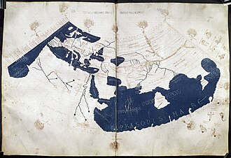
Ptolemy's World Map (c. 150 CE)
One of the earliest known world maps based on Claudius Ptolemy's Geographia, depicting the known world of the 2nd century.
Claudius Ptolemy's Geographia, written around 150 CE in Alexandria, contained instructions for mapping the known world using a coordinate system of latitudes and longitudes. Though the original maps were lost, they were reconstructed during the Renaissance from Ptolemy's descriptions. The map showed Europe, parts of Asia, and northern Africa, with significant distortions — notably underestimating the circumference of the Earth, which later influenced Columbus to believe he could reach Asia by sailing west.
Source: Library of Congress